Using a technique traditionally used in civil engineering, two seismologists, including Yann Klinger, a researcher at the Institut de Physique du Globe de Paris, have highlighted the stratigraphic succession of major earthquakes over the past 2,000 years south of the San Andreas fault in California. In this study, published at the beginning of July, they were able to identify variations in the seismic activity of the fault in this sequence, linked to the different historical water levels of the overlying lake, and thus better assess the rate of slip of this major fault in the western United States.
The Salton Sea is the largest freshwater reserve in southern California. Its level has varied considerably over time as a result of changes in the course of the Colorado River, with episodes of complete drying up, when the Colorado empties into the Gulf of California, and periods of filling well above the current level, when the river empties into the Salton Sea depression. The variations in this lake, also known as Lake Cahuilla, have been well documented and dated over the last few thousand years.
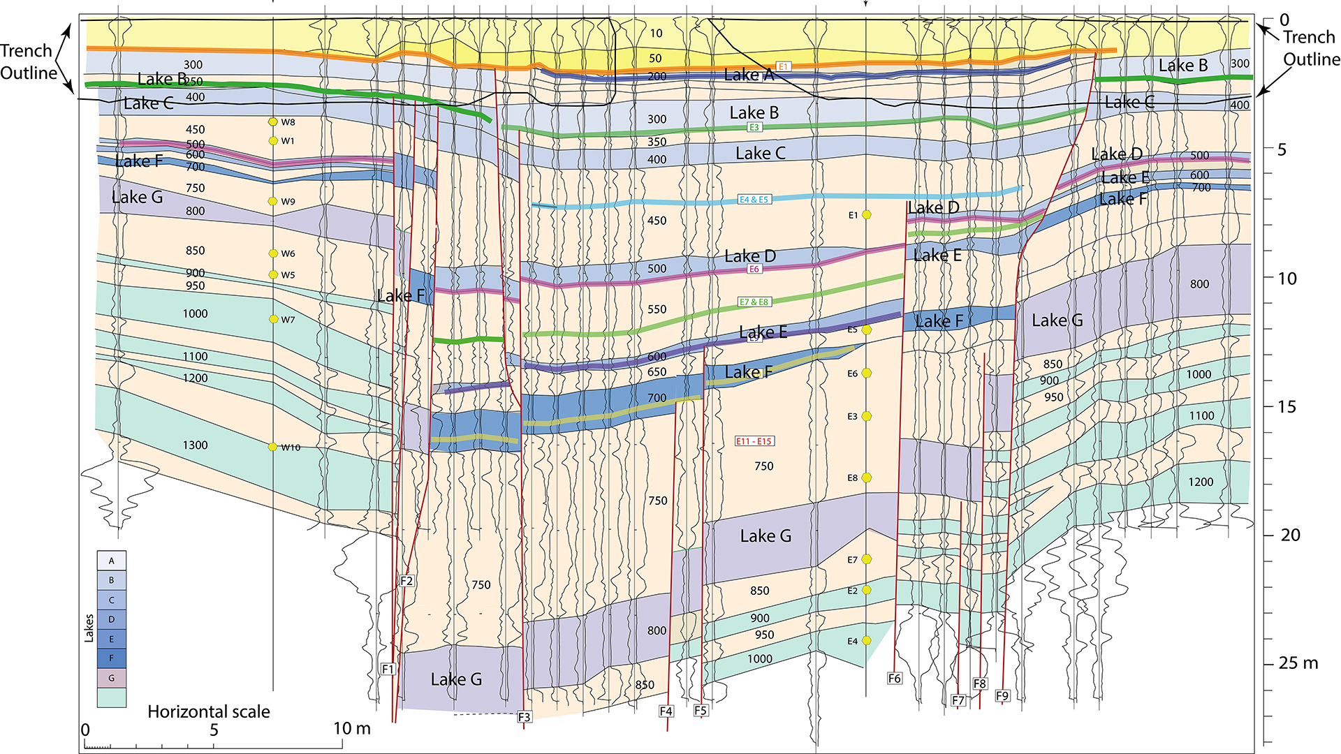
The authors, T. Rockwell (University of San Diego, California) and Y. Klinger (IPGP, Université Paris Cité, CNRS), of this study published in the journal Earth and Planetary Science Letters, have identified, on aerial photographs taken just after the Mw7 earthquake that affected the southern section of the San Andreas fault, the Imperial fault, in 1940, a small basin in extension favourable to the accumulation and preservation of sediments over time. Depending on the level of the Salton Sea, this small basin was either under lacustrine or alluvial depositional conditions. Using a drilling method commonly used in civil engineering (Cone Penetrative Test), the team determined the stratigraphic succession of deposits throughout the basin to a depth of 20m, and highlighted episodes of subsidence associated with major earthquakes in the past. By correlating the dating of shells collected in two cores taken from the basin and the chronology of the various high levels of Lake Cahullia, it was possible to establish a detailed chronology of the major earthquakes on this fault over the last 2,000 years. This chronology of major earthquakes shows that the temporal distribution of these major earthquakes is by no means regular over time.
As the two types of sedimentary deposits in the basin are easily distinguished by their composition and grain size (clay vs. sand and clasts), it has been possible to identify a very marked acceleration in seismicity around 1000 years ago, when Lake Cahullia filled up after a long period of drying up. Once the basin had refilled, seismicity returned to a more moderate level, suggesting a seismic response of the fault to the transient filling of the lake. Given the geometry of the fault, which lies in the middle of the lake, mass differential is not the preferred hypothesis for the factor controlling the temporary increase in seismicity, but rather the percolation of fluids in the fault zone which can, among other things, locally reduce the normal stress on the fault surfaces.
Furthermore, considering that the newly detected earthquakes in this study are all of approximately the same size, with horizontal displacements of a few metres, the authors propose that during this period of more intense seismicity, which lasted around 400 years, the slip-rate on this section of the fault must have been faster, reaching an estimated value of around 17 mm/year compared with 5 mm/year at present. Thus, the total deformation budget could have been largely consumed, which could explain the current absence of major earthquakes on the southern segment of the San Andreas fault.
Références :
> Thomas K. Rockwell, Yann Klinger, 2000 yrs of earthquakes inferred from subsidence events on the Imperial fault, California: Effect of lake-level changes and implication for variable slip rates, Earth and Planetary Science Letters, Vol 618, 2023, 118271, ISSN 0012-821X,
Read more

Leiden 2024, UPCité holds France’s top ranking for publication impact
Université Paris Cité maintains its position as the first French university, 16th in Europe and 37th worldwide for its publication impact according to the new Leiden rankings by the Centre for Science and Technology Studies (CWTS). The overall ranking includes 1,506...
read more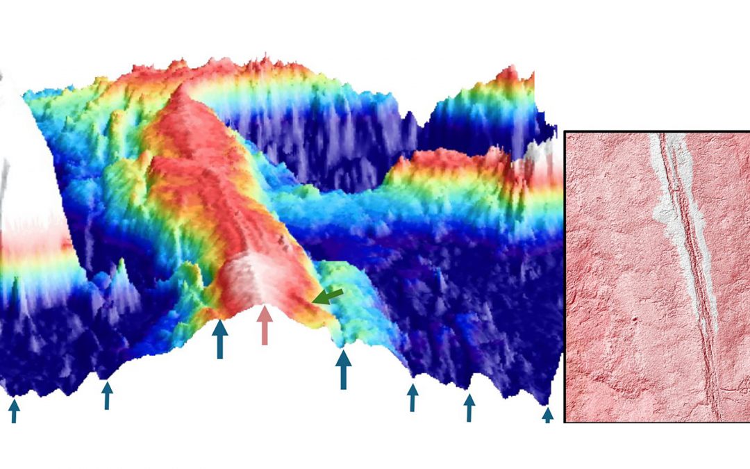
Evidence of magmatically induced faults at the East Pacific Rise
By comparison of ultra-high-resolution 3-D seismic imagery and bathymetry data collected at the East Pacific Rise (EPR) 9º50'N, researchers reveal the existence of magmatic induced faults near the ridge axis.
read more
Convergences: A Strategic Alliance paving the Future of Biology-Health Research
A key milestone for the partnership between Institut Pasteur and Université Paris Cité, the first “Convergences” scientific seminar took place on June 17th at the university’s head office at Odéon.
read more
Université Paris Cité receives 2 grants from Marie Sklodowska Curie Actions programme !
The results of the MSCA Staff Exchange 2023 call for proposals were published on May 28 2024. Université Paris Cité congratulates its two winners, Sylvain Chaty, Professor and Vice President for Culture, Science and Society at the AstroParticle and Cosmology...
read more